Petit lexique… pour ne pas se perdre
Definition of coastal zone
The coastal zone of Mauritius is legally defined in the Environment Protection Act:
“coastal zone”
(a) means any area which is situated within 1 kilometre or such other distance as may be prescribed from the high watermark, extending either side into the sea or inland;
(b) includes- (i) coral reefs, reef lagoons, beaches, wetlands, hinterlands and all islets within the territorial waters of Mauritius and Rodrigues; (ii) any estuary or mouth of a river and that part of a river, stream or canal which lies within 1 kilometre from the outermost point of its bank on the sea at high tide; (iii) the islands of Agalega and Saint Brandon, and other outer islets.
Environment Protection Act, as amended in 2017:
http://environment.govmu.org/English/Documents/EPA%20as%20amended%20in%202017.pdf
Distribution of coastline in mainland Mauritius
The coastline of mainland Mauritius is 322 km long.
Between 1990 and 2004, there has been an increase in the area of land for hotels and public beaches and a decrease in the area under agriculture and vegetation.
In 2004, hotels occupied about 48.6 km of the coastline of mainland Mauritius, while public beaches accounted for 28.9 km, together covering 24% of the coastline. According to the Mauritius Environment Outlook Report 2011, some 42 km were declared public beaches; no official figures are available for hotel sites after 2004.
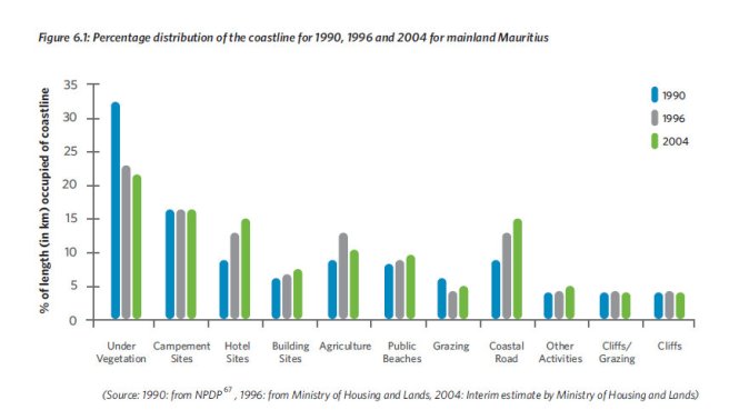
Source : Mauritius Environment Outlook Report 2011
State Land/ Terres de l’Etat : Selon le State Land Act, « State land includes defence lands, Pas Géométriques and all lands belonging to or in possession of the State. » Elles se situent sur la côte et aussi à l’intérieur de l’île. Elles peuvent être louées à bail ; le détenteur de bail a des droits (en tant qu’occupant il peut interdire l’accès au terrain) et des devoirs. Elles peuvent aussi être vendues, sauf dans quelques cas comme dans celui des Pas Géométriques qui ne peuvent être vendus (inalienable and imprescriptible).
Pas Géométriques Act
Pas Géométriques (PG) : Selon le Pas Géométriques Act, ce sont les « reserved lands » le long de la côte. La largueur des PG « shall be reckoned from the line of the seashore which is reached by high water at spring tide, and shall never be less than 81 metres and 21 centimetres.” Les PG font partie du domaine public et sont “inalienable and imprescriptible.” Les PG peuvent être loués à bail ; le détenteur de bail a des droits (en tant qu’occupant il peut interdire l’accès au terrain) et des devoirs.
Link to Pas Géométriques Act
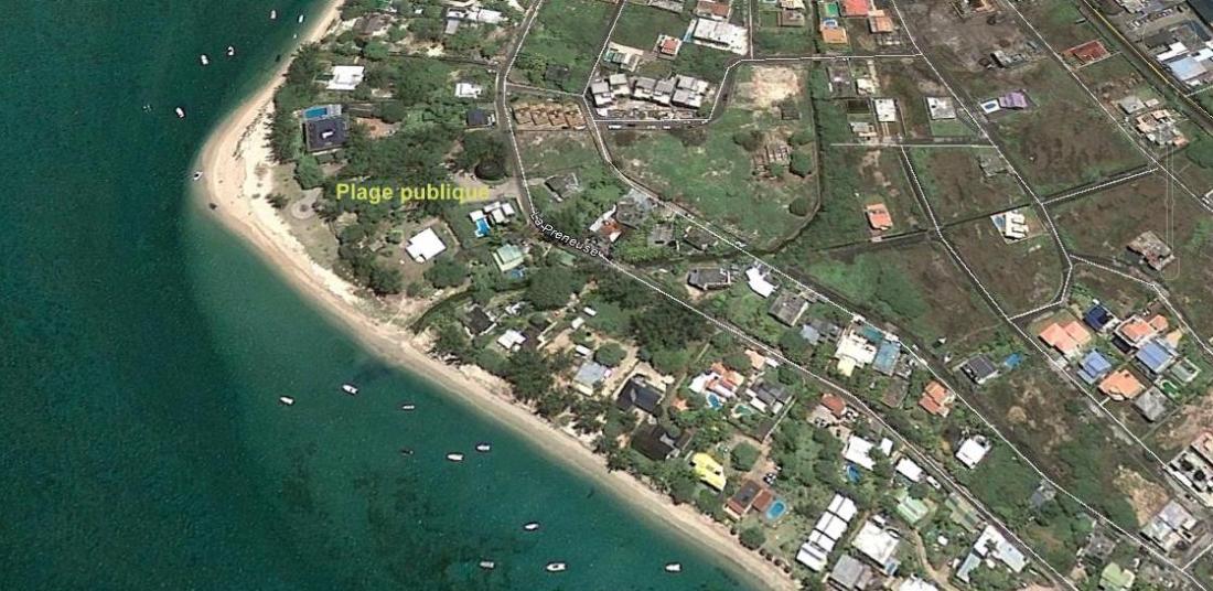
Plage (classifiée) publique : Les plages classifiées publiques sont les plages où l’accès et la circulation du public sont un droit ; l’usage est cependant règlementé par la Beach Authority (Use of Public Beach) Regulations 2004.
Selon la Beach Authority Act, un
“public beach” –
(a) means a space along the coast which, by notice published in the Gazette, has been declared to be a public beach by the Minister responsible for the subject of housing and lands; and
(b) includes the space between the low water mark and the high water mark, and also the surrounding waters up to a distance of 100 metres.”
http://extwprlegs1.fao.org/docs/pdf/mat52589.pdf
Les baux
Trois grands types de baux existent sur les Pas Géométriques : le Campement Site Lease, l’Industrial/Bungalow/Commercial Lease et le Agricultural Lease.
Sauf pour les plages proclamées publiques, la plus grande partie des Pas Géométriques est déjà louée à bail. Aussi, les PG qui pourraient être proclamées publiques sans une reprise ou résiliation de bail seraient ceux qui sont « uncommitted », c’est-à-dire, non alloués. Aucune information sur leur nombre ou superficie n’est disponible au public.
